Ngamadjidj Encounters with the Tappoc Gundidj, 1836-41
Benjamin Wilkie
Introduction
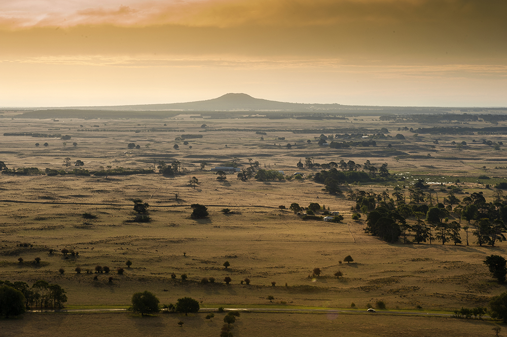
Formed when the lava flow and ejecta from a nearby volcano – Mount Napier – blocked a river valley, at its height Buckley Swamp covered around three-thousand hectares of land south of Hamilton in western Victoria. Buckley Swamp was not the largest or deepest wetland in the region, but it would figure prominently in the lives of the Tappoc gundij clan, who were Djab wurrung speakers and who called the volcano Tappoc and the swamp Konungiyoke. The swamp would cause the first ngamadjidj (white people) to visit the land great difficulties. George A. Robinson would, in 1841, pay a special visit to the swamp to meet the Tappoc gundij people, who had maintained their village and culture despite the ongoing pastoral invasion. Even with relatively extensive documentation of these encounters, however, the early history of Tappoc and Konungiyoke, or Mount Napier and Buckley Swamp, plays little role in contemporary understandings of the landscape.
This brief article retrieves a narrative of European encounters with Tappoc, Konungiyoke, and the Tappoc gundidj people from otherwise well-trod sources for the early history of the Port Phillip District. The aim of this article is twofold. First, it highlights an inherently important landscape in western Victoria. It provides a more detailed historical narrative for a site that is geologically unique and ecologically significant, but historically and publicly poorly recognised. Second, by adhering to relatively limited spatial, temporal, and archival boundaries, this article demonstrates the continuing value of more localised narratives of colonial encounters. The history of Tappoc and Konungiyoke, or Mount Napier and Buckley Swamp, reveals the surprising centrality of that landscape in otherwise well-known colonial meetings between Europeans and Aboriginal Victorians.
Mitchell and Tappoc
Setting out on 17 March 1836, Thomas Mitchell – the recently-appointed Surveyor General of New South Wales – and his party travelled south from New South Wales until they reached Pyramid Hill, north of present-day Bendigo, where Mitchell was enticed to explore further south. They followed Fenton’s Creek and Richardson River before journeying to Mount William and the Grampians, or Gariwerd. Mitchell then rode to the northernmost point of the ranges at Mount Zero and then on to Mount Arapiles before following the River Chetwynd and Crawford River to the Glenelg River. The party followed their route far south, where they encountered the Hentys near Portland on the coast before returning north in late-August.Mitchell first saw Tappoc on August 12, but only named it after ascending the hill he had named Mount Eckersley. ‘From this hill I recognised,’ he wrote on August 28, ‘a very conspicuous flat-topped hill to the northward which had been previously included in a series of angles observed on the 12th instant … and which I now named Mount Napier.’ On September 4, on his return north from Portland, Mitchell finally reached the vicinity of volcano. ‘I set out for Mount Napier and soon found the broad swamp before me,’ he wrote. ‘After riding up an arm of it to the left for a mile and a half I found it passable and, having crossed, we proceeded towards the hill.’ He described the countryside, particularly the numerous streams and creeks, and the swamps and wetlands they fed and drained, and saw evidence of a settlement belonging to the Tappoc gundidj people:
We next reached a deeper ravine where the land on each side was more open and also firmer, while a small rivulet flowing through it amongst bushes was easily crossed, and we ascended some fine rising ground beyond it. Rich flats then extended before us and we arrived at an open grassy valley where a beautiful little stream resembling a river in miniature was flowing rapidly. Two very substantial huts showed that even the natives had been attracted by the beauty of the spot and, as the day was showery, I wished to return if possible to pass the night there, for I began to learn that such huts with a good fire before them made very comfortable quarters in bad weather.
‘We had heard voices in the woods several times this day,’ wrote Mitchell, ‘but their inhabitants seemed as timid as kangaroos and not more likely to come near us.’ Continuing to ride towards the mountain, he noted that ‘blue mass of Mount Napier was visible occasionally through the trees, but I found as we proceeded that we were not so near it as I had supposed, for at three miles beyond the little stream we came upon one of greater magnitude, a small river flowing southward with open grassy banks’. The river flowed through a valley ‘where the forest land was remarkably open, being sprinkled with only a few trees as in a park, and this stream appeared to fall into the head of the extensive swamp’. After about a mile of riding beyond the river, Mitchell ‘came upon the extremities of Mount Napier’. All around the mountain, they met with ‘rough sharp-pointed fragments of rock laying about in heaps’ which made it ‘very difficult and tedious to ride over … The surface consisted wholly of this stone, without any intermediate soil to soften its asperity under the feet of our horses’. Riding across this terrain for three miles or more – the next day, their horses would have to be shod, ‘several shoes having come off on the rough rocks’ – Mitchell finally came to the base of the mountain. They proceeded to climb:
On the sides of it we found some soft red earth mixed with fragments of lava and on reaching the summit I found myself on the narrow edge of a circular crater composed wholly of lava and scoriae. Trees and bushes grew luxuriantly everywhere except where the sharp rocks shot up almost perpendicularly. The igneous character of these was so obvious that one of the men thrust his hand into a chasm to ascertain whether it was warm.
Mitchell wrote that the ‘discovery of an extinct volcano gave additional interest to Mount Napier, and hazarded to wonder if ‘this remarkable hill’ had ‘been in activity at no very remote period’. Over the coming days, Mitchell and his party would explore the surrounding area. On September 9, Mitchell climbed Tappoc again, this time ‘followed by a party of men with axes to clear its summit, at least sufficiently for the purpose of taking angles with the theodolite.’ From that vantage point Mitchell observed ‘two very extensive lakes in the low country between Mount Napier and the south-eastern portion of the Grampian range, which terminated in the hill that I had previously named Mount Abrupt. Between the largest of these waters (called by me Lake Linlithgow) and the mountains there appeared an extensive tract of open grassy land.’ He also looked to the east, where he saw ‘a solitary hill, somewhat resembling Mount Napier’, which he named Mount Rouse. The next day, on September 10, Mitchell measured the crater of Tappoc and, examining the volcanic ejecta in and around the crater, he observed that ‘all the stringy twisted marks of fusion were as sharp and fresh as if the lava had but recently cooled’.
All about the volcano, Mitchell and his expedition had encountered swamps. They ‘could not avoid the passage of various swamps or boggy soft hollows in which the carts and more especially the boat-carriage, notwithstanding the greatest exertions on the part of the men, again sank up to the axles.’ Eventually, their ‘boat-carriage could not be got out of the swamps and that, after the men had succeeded in raising it with levers and had drawn it some way, it had again sunk’. Stapylton reconnoitred the surrounding countryside and reported ‘a swamp of upwards of a mile in breadth and extending north and south as far as he could see lay straight before us’. Mitchell lamented that ‘Ere we could reach the nearest habitations of civilised men we had yet to traverse 400 miles of a country intersected by the highest mountains and watered by the largest rivers known in New Holland.’ After they had reached Tappoc and made their initial observations, upon returning to camp, Mitchell endured ‘a ride of twenty-six miles across swamps and many muddy hollows’. Over the coming days they would find themselves changing their route to avoid more swamps. Leaving Tappoc on September 11, they lightened their carts and pursued a circular route in avoidance of swampy ground: ‘Thus lightened we proceeded once more into the fields of mud, taking a northerly direction. For several miles we encountered worse ground than we had ever crossed before yet the carts came over it; but broad swamps still lay before us.’ Mitchell continued:
Despairing at length of being able to avoid them, I impatiently galloped my horse into one and the carts followed, thanks to my impatience for once, for I do not think that I should otherwise have discovered that a swamp so uninviting could possibly have borne my horse, and still less the carts. After this I ventured to pursue a less circuitous route.
Eventually, Mitchell and his party emerged from the swamps of Tappoc to the north, near present-day Hamilton. On September 11, he wrote:
a yellow flower in the grass caught my eye and, remembering that we had seen none of these golden flowers since we left the beautiful valley of the Wannon, I ventured to hope that we were at length approaching the good country at the head of that stream … I perceived through the trees a glimpse of an open grassy country, and immediately entered a fine clear valley with a lively little stream flowing westward through it and which I named the Grange. … we had at length reached the good country.
It is unclear whether he had seen the wetland that would become known as Buckley Swamp, but Mitchell had, nevertheless, investigated the volcano that caused that wetland to form after its eruption, and its surrounds.
Tyres and Konungiyoke
It was Charles Tyers, the surveyor and explorer, who provided the first explicit description of Buckley Swamp in the reports of his 1840 expedition into western Victoria on route to Portland. At the end of October 1840, Tyers reached Mount Rouse, where he ‘fixed several points of the Grampians, &c., angles to which had been taken from Mounts Elephant and Shadwell, and which, from their great elevation and well defined peaks, are of some importance in the survey.’ Some days later, on November 3, the party resumed its journey ‘in hopes of finding a passage between the great swamp (mentioned by Sir Thomas Mitchell) and Mount Napier, or, should that be found impracticable, to the southward of Mount Napier, heading the numerous swamps, the waters of which run into the long swamp.’ Unfortunately, Tyers could not pass. He would report:
When, having discovered that we were hemmed in on all sides by swamps and stoney ranges, we reluctantly returned to our old encampment under Mount Rouse, where we arrived in the afternoon of the 5th. From a small hill two miles to the northward of Mount Rouse, we perceived, extending from N. W. to the eastward of South, distant from one to six miles, innumerable swampy flats, all trending towards the great swamp. The only opening appeared between North and N. E. … On the morning of the 6th we proceeded about ten miles, in the northerly direction, towards Mount Abrupt, then altered our course to west … and avoided the swamps.
They encamped at the Grange Burn, near present-day Hamilton, and waited as a late-Spring storm passed. Then, on November 8, after crossing the Grange Burn, they ‘proceeded S. W. … through a thick forest intersected by numerous swamps, and arrived at Mr. Henty's road … on the 11th … We followed this road, crossing the Rivers Crawford, Fitzroy, and Surry, (obtaining angles and true bearings from Mount Eckersley) and arrived at Portland Bay on the evening of the 14th.’ Tyers stayed on the south-west coast over the Summer. In his final report, he would observe that ‘Between Mounts Rouse and Napier is some fine country, but the greater portion consists of swamps; Mount Rouse is of trap formation; the soil in its neighbourhood is good.’ Confirming the landscape that Mitchell had encountered, he wrote that ‘The greater part of Australia Felix, which we traversed, is evidently of igneous origin. Many of the hills are composed of trap, scoria, and very hard cellular ferruginous sand stone. Between Mounts Rouse, Napier and Sturgeon, fragments of trap in great quantities protrude from the surface … Mount Napier is surrounded by sharp angular fragments of trap.’
Robinson and the Tappoc gundidj
It was George Augustus Robinson who, as Chief Protector of the Aborigines, met with and took detailed notes about the Djab wurrung speakers who lived near the swamp at the base of the volcano – the Tappoc gundidj people. At the start of May 1841, having already travelled west from Melbourne since March, Robinson expressed interest in meeting with the Aboriginal people who lived at Mount Napier. At Mount Rouse, a Mr Scott told Robinson that he ‘had travelled in all directions 700 miles, and had only seen five or six natives and these together near Pyreenees.’ An Aboriginal informant told him, on the other hand, that he ‘was plenty sulky with Tappoc natives, they killed his brother’, while he had received information elsewhere that ‘the natives were numerous at Mt Napier.’ In either case, on Sunday, May 9, wrote Robinson, ‘the natives consented to go with me by Tyers’ new road to Furlong’s cattle station and then to Tappoc.’ They were to travel west from Lake Linlithgow and south through the Grange Burn station on the site of present-day Hamilton, which the Wedge brothers had sold to Andrew and William Forlonge in the previous year. David Edgar, who had arrived in Port Phillip in 1838, managed the property.
‘Rode on to an out station of Forlong’s,’ wrote Robinson. ‘Tyers’ line joins the old road here. There is a small hill two or three miles from this station from the top of which you get a fine view of the good country westward. The Glenelg and the hills beyond are visible. Crossed a creek called Muddy Creek. Crossed also a second creek called Murphy’s Creek’. Here, the party ‘Passed the frame of a small native hut’, which Robinson observed was ‘made very substantial and neat and placed on the slope or declivity of a hill with an oven at the back.’ Edgar and Robinson rode around the creeks and swamps, where they saw ‘several native worns [wuurns] or huts, one 10 feet in diameter.’ Robinson was informed that the creek at which he, Edgar, and the party had arrived at ‘is a favorite resort of the natives in summer season for catching birds. Passed several waterholes where at the natives had been catching birds. This creek contains, like most others, a chain of holes and in dry weather few contain water. The holes with water are then selected by the natives for catching birds.’
Making their way to the dairy or cattle station owned by the brothers Forlonge, Robinson’s group continued along the road, south, towards Portland Bay. Before coming to the station, Robinson noted that they saw ‘several interesting spots’. They met, on their arrival, Donald Cameron from Mount Sturgeon Plains and either Donald or Duncan Kennedy, who owned Hyde Park north of Cavendish and Linlithgow Plains south of Dunkeld. ‘They had arrived the day before across the river from the plains, passed Napier to a large swamp which they had supposed, when seen from Mt Napier, to have been good land,’ recorded Robinson. Cameron and Kennedy reported ‘that they had seen numerous natives and native camps round the swamps but they had offered them no molestation.’ Robinson said that the ‘swamp was reported to be of great magnitude … The country round it was said to be well grassed and fine for cattle.’ At the station, furthermore, there was ‘a fine spring, the only water on the creek. The natives, therefore,’ thought Robinson ‘are deprived of their water. A whole village, therefore, have been forced away from their ancient pool.’ Robinson and his party sought out more of these villages the next day.
On Monday, May 10, they set out again – ‘with my eight Aboriginal attendants, one VDL native, one white servant, two horses and presents’ – to establish contact ‘with the Tappoc conedeet or Mt Napier natives.’ Following the creek for about one and a half miles, they found ‘fresh indication of natives. This place, previous to its occupation by white men, was a favorite resort and as this was the only perminent supply of water, a village had been formed.’ Robinson continued his description of the village and its buildings:
I counted 13 large huts built in form of a cupola. …they have the appearance of mounds of earth. They are built of large sticks closely packed together and covered with turf, grass side inwards. There are several variations. Those like a cupola are sometimes double and have two entrances; others again are like a niech. Then there are some made of boughs and grass. And last are the common screens. The permanent huts are those in form of a cupola. Three of these huts had been occupied a day or two previous to my visit. A shield or, in the language of the natives, por.ral, as also a bucket or po.pare.re, and a shield of boughs for catching birds were left at the huts.
On another day, Robinson further recorded that on his way to ‘the great swamp’ he ‘passed at least 20 well built worns [wurrns] or native huts. Some were placed near the river, others on aclivity of the hills, and some on the top of an emminence. One on the top of an emminence was erected on a mound of earth’. On their initial excursion, however, they continued up the creek. Robinson observed that ‘Old indications were very numerous. Large holes had been cut for oppossum and small holes for [blank] or grubs.’ After four miles, they came to ‘an arm of the great swamp’ noted by Kennedy and Cameron. Robinson’s Aboriginal guides ‘descried three natives near the edge of the swamp’ and a further ‘two natives walking on the opposite [side] of the swamp, in the forest. They had not seen us.’ Sending his guides to meet with the Tappoc gundidj people, Robinson examined the edges of the great swamp. ‘The ground on the swamp was pulpy and soft like sponge but at the present could not be said to be swamp as it was dry,’ he wrote. As he rode around the swamp, ‘Tappoc at several points between the dairy station and swamp shewed itself. It was easily seen from the eminences round the swamp.’ Continuing, he related how he:
rode along the swamp and on the top of the highest ground the swamp extended on further than I could see and I observed many large arms or inlets branching off. It is of considerable extent. The swamp near to Tappoc is as nothing to it. I scarcely think Mitchell saw this swamp. It was not known at the cattle station at Furlong’s although the first branch was not more than five miles off … The creek that runs past the dairy station called by the natives Ar.ren.doo.rong: and which runs from the swamp to the dairy station in a northwest direction. Is one of the drains of the swamp.
Robinson noted how ‘the face of the whole country had been burnt and the rushes of the swamp and the young grass, anchistiria, had attained to a growth of seven or eight inches and a most verdant appearance.’ He observed how the ‘land round the swamp is elevated and undulating, of good quality and lightly timbered. It is a very fine country and the scenery beautiful … It is a beautiful cattle country.’ He recorded the name of the great swamp: ‘Ko.nung.i.yoke.’
Robinson also found evidence of a Tappoc gundidj settlement. He recorded how he came across ‘a fine large double hut, 10 feet diameter with two entrances and four feet high in centre. I went in at one door and came out of the second.’ He described a ‘native well, about 2½ deep’ with water: ‘The hole was about a foot wide at top. To get the water out of such holes the drinking reed is indispensable. Besides which, the water can be obtained without disturbing the sediment. Grass is laid in the well and the water filters through it.’ Later in his trip, Robinson would note that the ‘great swamp abounds in rushes the roots of which are edible and afford the natives an ample supply and is one of their chief supports. When roasted in the fire is meally and white, like flour. There is another root also they get from the swamp called tar.roke.’
Of the Tappoc gundidj people themselves, Robinson observed and recorded a great deal. Once his Aboriginal guides had met the first ‘three strangers, the rest of the natives, who had been previously concealed, showed themselves and informed me the strangers were females.’ He noted that ‘Two of them carried, besides a basket of food, two infants on their backs … two of them were far advanced in pregnancy. One that had an infant was quite a girl’ and was ‘clad in an old shred of a dirty blanket.’ Robinson ‘shook hands and patted their heads.’ He took the names of two of the Tappoc Gundidj women and their children: ‘Pac.cun.nuc, or, Wor.rone.beer.rang’; ‘Weer.re.ween, or, Yal.ler.ro.been’; ‘Moorngal, an infant daughter to [Weer.re.ween]’; and ‘Keer.re.chur.re.meen, or, Mor.ro.cort … also an infant.’
After he had surveyed the swamp, he met with ‘a party of natives …wending their way through among the trees in the forest on the opposite side of the swamp.’ ‘When the natives appear’, he wrote, ‘I brake through all Aboriginal cerimony, (which to observe would be a waste of time) and go forth and meet them.’ He also recorded their names and ages: ‘Ware.ren.gort’ (33); ‘Ware.ren.gort, the young son to [Ware.ren.gort]’ (15); ‘Hume.hume’ (9); ‘Til.le.cur.meen’ (9); ‘To.lone.oo.rort’; ‘Ne.ter’ (19); ‘Curt.be.durk, infant, 10 months’; and ‘Mim.yare.an.yare’ (31). One of his Aboriginal guides gave him the names of Nillan gundidj people who lived southwest of Tappoc, in addition the names of some further Tappoc gundidj men: Wane.oo.corn. Wan.de.boke, Wor.rem.doo.rat, Wy.ren.nor.rer, Cur.re.mud.doke, Wane.boom, Ar.re.mut.tom, Cor.rer.beet.mur.ri, and Pang.ut.mar.re. In all, Robinson would list the names of fifty-nine Tappoc gundidj people, including seventeen men, twenty-one women, and twenty-one children.
‘After taking their names and welcoming the strangers and, further to establish confidence, I made each a present of beads, medals, handkerchief; the men as well as the women,’ wrote Robinson. He regarded the meeting as one of significance, writing that ‘Although the party I had conferred with was small it nevertheless was a great thing accomplished as I was now assured the purpose of my visit would be made known to the Tappoc tribe even although I should not meet any more … My mind is now at ease and I feel satisfied. Providence has crowned my endeavours with success.’ The next day, Tuesday, May 11, riding out to the swamp, he came across a ‘party of women and children collecting food - murnong and grubs’ who invited him to their camp, where he took the names of a further twenty-four Tappoc gundidj people living there. ‘Most of all the women were pregnant,’ he wrote, further remarking that ‘The women of this tribe are extremely prolific; most of them are enceinte [pregnant]’.
Robinson made some further, sporadic observations about the Tappoc gundidj people during the few days he was with them. The first party he met with ‘had lighted torches in their hands. The weather was cold and this is their custom when travelling, to keep themselves warm’. He noted that the men he met with were unfamiliar, and much amused, by his horse; that they were unfamiliar with brewed tea; and, that ‘They have no word to express a European. Their distinguishing appellation seems to be “white man, white fellow”.’ He would observe that ‘these people are very suspicious and have had no intercourse with Europeans’. The next day, meeting with the larger group, Robinson made observations about Tappoc Gundidj families: ‘when noting their names, they [took] particular pains to let me know what women and children belonged to them. Each man gathering round himself those who belonged to him and each had a tolerable family. Pollygamy appears more common with this tribe than with others.’ Overall, Robinson’s meeting with the Tappoc gundij people warranted extended reflection in his journals. The day before departing from them, he would write:
Such a meeting had never before been held with these people, either within or out of their district. Nor had my most sanguine expectations anticipated such an event in so short a time. What had been done in seven weeks: several savage natives had been conferred with and part of their language and history and customs and habits had been acquired. Even this part of the country ie., the great swamp, had not been known to Furlong’s stockkeeper at dairy station until yesterday.
The next day, Wednesday, 12 May, Robinson and his party prepared to depart Tappoc. Moved, he wrote: ‘I saw the tear of affection trickelled down the sable cheek of these Mt Napier natives. These, reported to be, so savage and terrible a people and so fierce in their hatred to the white inhabitants. I saw the affectionate embrace of the men towards each other and of the women towards their own sex: more forcible than the cold shake of the hand of the white man.’ On the Thursday, they left to continue the journey to Portland Bay.
Conclusion
Between 1836 and 1841, Mitchell, Tyers, and Robinson – and their expedition parties – had all visited the sites that would become known as Mount Napier and Buckley Swamp. Mitchell and Tyers, despite their grievances, provided valuable observations about the physical environment they found. Robinson furnished important details of the Tappoc Gundidj people, observations which contributed to the larger body of knowledge about Djab wurrung and other western Kulin people in the Western District of Victoria and they ways in which they lived. Read closely, with spatial and temporal limits in mind, these sources are still valuable materials for developing a finer-grained understanding of Victoria’s early history.